Embedding & Sharing
GeoLibre's browser build can be embedded in any web page and configured through URL query parameters. This is how you turn a shared project into a live, focused map for a website, a report, or a dashboard.
The live viewer
The browser build is hosted at https://web.geolibre.app/. It is a static site deployed on GitHub Pages that runs entirely in your browser: it has no analytics and no server account, and the data you load is processed client-side. Data leaves your browser only when you add a remote URL or explicitly share a project.
Open a public project by passing its .geolibre.json URL with the url parameter:
https://web.geolibre.app/?url=https://share.geolibre.app/giswqs/3d-tiles.geolibre.json
A project URL like this comes from Project → Share. See Projects.
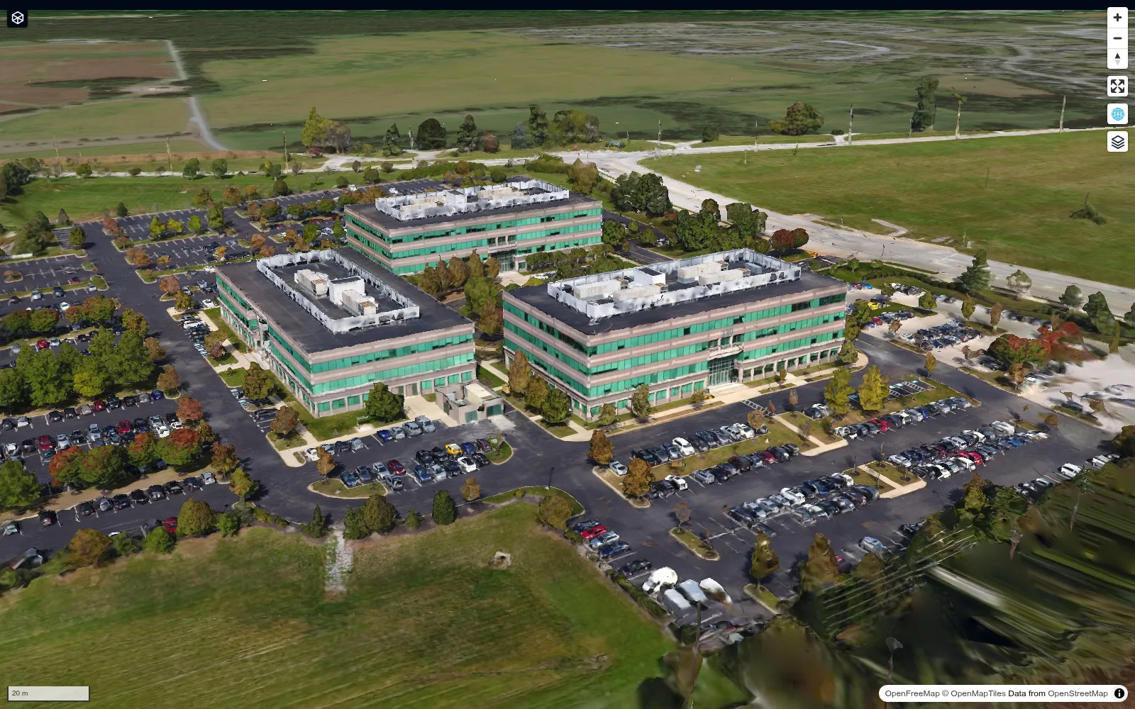
A chrome-free maponly embed shows only the map, as in this shared 3D Tiles project:
URL parameters
| Parameter | Example | Description |
|---|---|---|
url |
url=https://share.geolibre.app/you/project.geolibre.json |
Loads a .geolibre.json project from a public URL. |
data |
data=https://assets.geolibre.app/data/places.geojson |
Loads public GeoJSON, GeoParquet, PMTiles, a COG, or a ZIP/REST response containing multiple GeoJSON files. |
style |
style=https://assets.geolibre.app/data/sample.style.json |
Applies a GeoLibre/MapLibre vector style or raster-style JSON to the data loaded by data. |
layout |
layout=viewer |
viewer provides read-only chrome: Layers, View, Controls, basemaps, search/identify, and Help, with authoring UI hidden. compact is the icon-only full-app layout; embed and iframe are aliases. |
toolbar |
toolbar=icons |
Icon-only toolbar buttons without the full compact layout. icon and icon-only are aliases. |
panels |
panels=collapsed |
Starts Layers and Style collapsed to their icon rails. Use none to hide all panels; hidden, hide, and off are aliases. |
hidePanels |
hidePanels=true |
Alternative way to hide those panels. |
maponly |
maponly |
Hides all chrome (toolbar, panels, and status bar), leaving only the map. The bare flag or true, 1, yes, on enable it. |
welcome |
welcome=0 |
Hides the first-launch welcome wizard. Accepts 0, false, off, or no. A url= or data= deep link already suppresses it automatically. |
theme |
theme=dark |
Sets the initial color theme, overriding the OS preference. Accepts dark or light; the in-app toggle still works afterward. |
tool |
tool=adaptive_filter |
Opens the Processing (Whitebox toolbox) dialog on a specific tool by its id. Unknown ids open the dialog without preselecting a tool. |
Private projects and data
url= and data= are fetched by the browser with same-origin credentials,
so a project or dataset gated by a session cookie loads only when GeoLibre is
served from that same origin. Passing a login-protected URL to the hosted
viewer at web.geolibre.app fails, because the cookie is not sent
cross-origin. Serve the app from your own host, or use a signed, expiring
URL. See Self-Hosting & Private Data.
Parameters combine. For a narrow, chrome-free, dark embed of a shared project:
https://web.geolibre.app/?url=https://share.geolibre.app/you/project.geolibre.json&maponly&theme=dark
Deep-linking a Processing tool
tool=<id> opens the Processing (Whitebox toolbox) dialog preselected to a tool.
Any additional query parameters pre-fill that tool's form, using the tool's
own parameter names, so a link can arrive ready to run:
https://web.geolibre.app/?tool=extract_cog_subset&url=https%3A%2F%2Fdata.source.coop%2Fgiswqs%2Fopengeos%2Fdem.tif&bbox_crs=4326
When tool= is present the app is in tool mode: url names a tool input
(here, the COG to subset) rather than a project to load, so the project loader
stands down. App/embed parameters above (theme, layout, panels, maponly,
locale, …) keep their own meaning and are never passed to the tool.
Preselection and parameter prefilling apply only to an id that matches the
Processing menu: an id not in the menu still opens the dialog, but without
preselecting a tool or applying any parameters. A known id the current engine
doesn't expose (WASM in the browser, the Python sidecar on desktop) likewise
isn't preselected. Tool ids match the Processing menu — the same ids used across
the Whitebox toolbox.
Embedding in a page
Drop the viewer into an <iframe>:
<iframe
src="https://web.geolibre.app/?url=https://share.geolibre.app/you/project.geolibre.json&maponly"
title="GeoLibre map"
width="100%"
height="600"
style="border: 0;"
loading="lazy"
allow="fullscreen; geolocation"
></iframe>
Use layout=viewer for a read-only map with layer toggles, search/identify, and
basemap switching. Its layer list mirrors the authoring Layers panel, folders
and all, so group names carry over. The Controls menu is part of the viewer
chrome, minus the two entries that write to the project (Field Collection and
GPS Tracking); Record Tour and Record Video only read the map, so they stay.
Read-only covers the keyboard too: the
project shortcuts (Ctrl/Cmd+N, +O, +S) and the command palette (Ctrl/Cmd+K) go
with the menus they belong to, while the View shortcuts ([, ], n, u,
r) keep working since the View menu stays. Dropping a file onto the map
imports nothing, and the plugins whose on-map control writes to the project —
the geometry editor, Annotations, and GeoAgent — cannot be active, even if the
loaded project saved them that way.
So an embed cannot be steered into authoring by a key press, a drag, or a
project file. Display plugins (layer control, basemaps, time slider, legend and
colorbar components) keep working, so the project still looks as it was saved. Use layout=compact for the complete authoring
toolbar in a smaller space, or maponly for a pure map.
Open remote data
Use data to open public GeoJSON, GeoParquet, PMTiles, Cloud-Optimized GeoTIFF (COG), or a ZIP archive containing one or more .geojson/.json FeatureCollections. Each GeoJSON file in a ZIP becomes a separate layer. An optional style URL applies Mapbox/MapLibre style JSON to vector data:
https://web.geolibre.app/?data=https://assets.geolibre.app/data/places.geojson&style=https://assets.geolibre.app/data/sample.style.json
data may also point to a REST API endpoint that returns either a GeoJSON FeatureCollection or a ZIP containing multiple GeoJSON files. ZIP API responses are recognized from their Content-Type/Content-Disposition headers or their ZIP file signature, so the endpoint does not need a .zip suffix. An endpoint that takes its own query parameters is the case that does need percent-encoding, so its & separators are not read as GeoLibre's own:
https://web.geolibre.app/?data=https%3A%2F%2Fapi.example.com%2Ffeatures%3Fcategory%3Dparks%26limit%3D100
The example API URL is illustrative. Use the hosted places.geojson example above for a directly runnable test.
A hosted ZIP with per-file styles can be tested directly:
https://web.geolibre.app/?data=https://assets.geolibre.app/data/multiple-layers.zip&style=https://assets.geolibre.app/data/multiple-layers.style.json
GeoParquet is loaded through GeoLibre's DuckDB-backed vector reader. PMTiles is streamed with HTTP range requests and may contain either vector or raster tiles. These real vector examples also apply the hosted sample style:
https://web.geolibre.app/?data=https://data.source.coop/giswqs/opengeos/building_count_h3.parquet&style=https://assets.geolibre.app/data/sample.style.json
https://web.geolibre.app/?data=https://data.source.coop/giswqs/opengeos/building_count_h3.pmtiles&style=https://assets.geolibre.app/data/sample.style.json
For a vector PMTiles archive, the style is applied to the layer after the archive's source layers are discovered. A raster PMTiles archive can be loaded with data, but it does not accept a MapLibre vector style through style.
A public DEM COG can be tested directly:
https://web.geolibre.app/?data=https://data.source.coop/giswqs/opengeos/dem.tif
A plain https://… URL can be passed as-is, as above: : and / are legal in a query value and need no escaping. Encode the nested data and style URLs with encodeURIComponent only when they contain a character that would be read as GeoLibre's own query syntax — &, +, %, or #. A bare = inside the value is fine, since only the first = in each &-delimited pair separates the name from the value. Remote servers must permit browser cross-origin requests (CORS). COG, GeoParquet, and PMTiles servers should also support HTTP byte-range requests.
For a COG, style may point to a raster style JSON object. Supported fields are mode (single, rgb, or index), 1-based bands, rescale ranges, colormap, reversed, nodata, opacity, gamma, stretch (linear, log, or sqrt), and the normalized-difference index preset. For example:
{
  "mode": "single",
  "bands": [1],
  "rescale": [[0, 1000]],
  "colormap": "viridis",
  "reversed": false,
  "nodata": "auto",
  "opacity": 0.85,
  "gamma": 1,
  "stretch": "linear"
}
After hosting that JSON as dem.style.json, pass both URLs:
https://web.geolibre.app/?data=https://data.source.coop/giswqs/opengeos/dem.tif&style=https://assets.geolibre.app/data/dem.style.json
For a ZIP containing files of the same geometry type, assign different styles by setting each Mapbox style layer's source to the corresponding filename stem. For example, source: "parks" targets parks.geojson, while source: "counties" targets counties.geojson. Style layers without a source are shared by every imported file. GeoLibre validates all filename/style matches before adding any ZIP layers.
You do not need to author that JSON by hand. Open the vector layer's Layer actions → Styles → Export GeoLibre URL style menu. The downloaded .geolibre.style.json contains only symbology—not feature data—and its render-layer source is already set to the original GeoJSON filename stem. Host the file on a CORS-enabled server and pass its URL as style alongside the corresponding data URL. For a multi-file ZIP, export each layer's GeoLibre URL style and combine their layers and sources into one style document; layers without source can be used for rules shared by every ZIP member.
The same file can be applied interactively to an existing vector layer through Layer actions → Styles → Import style (GeoLibre URL / Mapbox GL / SLD / QML)…. Interactive import ignores the file's query-param source binding and applies its supported symbology to the layer you selected, so the data filename does not need to match.
An "Open in GeoLibre" badge
If you publish a dataset — in a repository README, a data catalog, a paper's supplementary material — an Open in GeoLibre badge turns it into a one-click interactive map. Copy one of these and swap in your own URL:

[](https://web.geolibre.app/?data=https://assets.geolibre.app/data/places.geojson)
The same badge can open a shared project instead of a single file, using url:
[](https://web.geolibre.app/?url=https://share.geolibre.app/you/project.geolibre.json)
In reStructuredText:
.. image:: https://img.shields.io/badge/Open%20in-GeoLibre-green.svg
   :target: https://web.geolibre.app/?data=https://assets.geolibre.app/data/places.geojson
   :alt: Open in GeoLibre
In HTML:
<a href="https://web.geolibre.app/?data=https://assets.geolibre.app/data/places.geojson">
  <img src="https://img.shields.io/badge/Open%20in-GeoLibre-green.svg" alt="Open in GeoLibre" />
</a>
Add any of the URL parameters to the link to control how the
map opens — &style= for symbology, &theme=dark, or &maponly for a
chrome-free view.
One caveat specific to badges: a badge lives in a README.md that GitHub, PyPI,
and docs sites all render, and each of those rewrites relative links
differently, so keep the target URL absolute. The encoding rule above
applies unchanged — a data URL carrying its own query string still needs
encodeURIComponent, because the & is read as GeoLibre's own separator well
before the browser ever sees it.
Talking to the map at runtime
URL parameters configure the app once, at load. To keep talking to a live
embed (fly to the record the user just clicked in your app, highlight it, open a
processing tool) and to hear what the user does inside the map, use the embed
postMessage API. The dependency-free @geolibre/embed package provides the
recommended typed client and handles origin checks and request correlation:
import { connect } from "@geolibre/embed";

const map = await connect(document.querySelector("iframe"), {
  origin: "https://web.geolibre.app",
});
await map.setView({ center: [-95.7, 37.1], zoom: 5 });
await map.setLayerVisibility("roads", false);
const layers = await map.listLayers();
map.on("selectionChanged", ({ featureIds }) => console.log(featureIds));
Enabling it
The API is off by default: a public deployment can never be driven by the page that frames it. Turn it on by naming the origins you trust. For the Docker image, that is one environment variable:
docker run --rm -p 8080:80 \
  -e GEOLIBRE_EMBED_ORIGINS="https://portal.example.com,https://erp.example.com" \
  ghcr.io/opengeos/geolibre:latest
For a static build, bake it in instead:
VITE_GEOLIBRE_EMBED_ORIGINS="https://portal.example.com" npm run build.
Entries are origins (scheme://host[:port]); a trailing path is ignored. *
allows any origin and is only appropriate on a private network. The allowlist is
enforced in both directions: a message from an unlisted origin is ignored, and
every message the app sends is addressed to a listed origin. (With *
configured, outbound messages are addressed to * until the host's first
message identifies it, which is one more reason to name your origins.)
Setting the allowlist also narrows the ?embed=1 project/scripting bridges (used
by the Python package) to the same origins. As extra hardening
you can stop other sites from framing the app at all by adding
Content-Security-Policy: frame-ancestors <your origins> at your reverse proxy.
The typed client
@geolibre/embed is a dependency-free ESM package published to npm from each
GeoLibre release, so its version tracks the app version:
npm install @geolibre/embed
connect(iframe, options) returns a promise that resolves once the app sends
ready, so there is no ready handshake to write yourself. It also stamps a
requestId on every command and settles that command's promise from the
matching ack, which is what lets several commands be in flight at once
without their answers getting crossed.
import { connect } from "@geolibre/embed";

const map = await connect(iframe, {
  origin: "https://web.geolibre.app", // exact origin hosting the iframe
  timeoutMs: 15_000, // wait for `ready`; default 15s
  requestTimeoutMs: 15_000, // wait for each `ack`; default 15s
});
origin is required and must be an http(s) origin: it is both the target of
every outbound message and the filter on inbound ones, so a message from any
other frame or origin is ignored. Pass the app's origin, not your own.
| Method | Resolves with | Notes |
|---|---|---|
loadProject(url) |
void |
Swaps the project without reloading the iframe. |
setView(target) |
void |
{ bbox }, or any of { center, zoom, bearing, pitch, duration }. |
highlightFeature({ layerId, … }) |
void |
featureId, featureIds, or filter; fit: true zooms to the match. |
openTool(id, params?) |
void |
Runtime twin of ?tool=. |
setLayerVisibility(layerId, visible) |
void |
Shows or hides a project layer. |
listLayers() |
LayerSummary[] |
{ id, name, type, visible, opacity } per layer. |
setFilter(layerId, expression) |
void |
A MapLibre filter expression, or null to clear it. |
getViewport() |
Viewport |
{ bbox, center, zoom, bearing, pitch }. |
addLayer(spec) |
the new layer's id |
Takes a project-format layer specification. |
exportImage() |
a PNG data: URL |
The map as currently rendered. |
on(event, listener) |
an unsubscribe function | Not a promise; events are the set the app posts (see below). |
disconnect() |
not a promise | Removes the listener and rejects anything still in flight. |
Every command rejects rather than resolving falsely: an ack carrying
ok: false rejects with the app's own error message, and a command with no
answer inside requestTimeoutMs rejects with a timeout. connect itself
rejects if ready does not arrive inside timeoutMs — most often because the
deployment has not allowlisted your origin, or because origin does not match
the iframe.
Call disconnect() when you tear the iframe down (a React effect cleanup, a
route change). It stops the message listener and rejects every pending
command, so a promise cannot hang for the life of the page.
on returns its own unsubscribe function and accepts every event in the table
below, typed by name. Subscribing to ack is only worth it
to observe the traffic, since each command's promise is already settled from it.
Hosts that cannot take a dependency can speak the protocol directly; the rest of this page documents it.
Message shape
Every message, in both directions, is versioned:
{ "v": 2, "type": "setView", "payload": { "center": [-95.7, 37.1], "zoom": 5 } }
Messages the app sends also carry "source": "geolibre", so you can filter
them out of the other postMessage traffic on your page.
Host to GeoLibre
| Type | Payload | Effect |
|---|---|---|
loadProject |
{ url } |
Loads a .geolibre.json project without reloading the iframe. |
setView |
{ bbox } or { center, zoom, bearing, pitch, duration } |
Fits a bounding box, or flies the camera to the properties you send. |
highlightFeature |
{ layerId, featureId \| featureIds \| filter, fit } |
Selects and highlights features; filter matches properties. fit zooms to them. |
openTool |
{ id, params } |
Opens the Processing dialog on a tool, pre-filling params. Runtime twin of ?tool=. |
setLayerVisibility |
{ layerId, visible } |
Shows or hides a project layer. |
listLayers |
{} |
Returns layer summaries in the acknowledgement's result. |
setFilter |
{ layerId, expression } |
Applies a MapLibre filter expression; send null to clear it. |
getViewport |
{} |
Returns the current camera and bounds in result. |
addLayer |
{ spec } |
Adds a project-format layer specification at runtime. |
exportImage |
{} |
Returns the rendered map as a PNG data URL in result. |
Send { layerId } alone to highlightFeature to clear the highlight. A request
that names features (or a filter) but matches none is rejected rather than
treated as a clear, so a mistyped id does not silently wipe the user's selection.
Highlighting reads the layer's features from the project, so it applies to vector
layers GeoLibre holds as GeoJSON, not to ones whose features live only in a tile
source.
setFilter compiles the expression through the MapLibre style spec before
storing it, and addLayer requires a source the map can actually read: a url
or a non-empty tiles, or — for the two layer types drawn from inline features,
geojson and deckgl-viz — an inline geojson. Both report the problem in the
ack rather than reporting success and rendering nothing. addLayer also
refuses javascript:, vbscript:, data:, file:, and blob: URLs on a
source; a custom map protocol such as pmtiles:// is fine.
Add a requestId to any message and the app answers with an ack (below)
reporting whether it worked.
GeoLibre to host
| Type | Payload | Fires when |
|---|---|---|
ready |
{ version } |
The app has mounted and is listening. |
ack |
{ requestId, ok, error, result } |
A message you sent with a requestId was applied (or rejected). |
projectLoaded |
{ url, name, layerIds } |
A project finished loading, whoever started it. |
selectionChanged |
{ layerId, featureIds } |
The user (or your highlightFeature) changed the selection. |
viewChanged |
{ bbox, center, zoom, bearing, pitch } |
The camera moved (throttled to about four events a second). |
toolCompleted |
{ id, name, status, engine, durationMs, outputLayerNames } |
A processing run finished, successfully or not. |
serverFileWritten |
{ path, toolId } |
A file-based tool wrote an output (conversion and raster tools). |
A host page
<iframe
  id="map"
  src="https://gis.example.com/?url=https://erp.example.com/fields.geolibre.json&maponly"
  title="GeoLibre map"
  width="100%"
  height="600"
  style="border: 0"
></iframe>

<script>
  const frame = document.getElementById("map");
  const APP_ORIGIN = "https://gis.example.com";

  const send = (type, payload) =>
    frame.contentWindow.postMessage({ v: 2, type, payload }, APP_ORIGIN);

  window.addEventListener("message", (event) => {
    if (event.origin !== APP_ORIGIN) return;
    const message = event.data;
    if (message?.source !== "geolibre" || message.v !== 2) return;

    if (message.type === "ready") {
      // Safe to start sending commands.
    } else if (message.type === "selectionChanged") {
      showRecordFor(message.payload.featureIds[0]);
    }
  });

  // Click a record in your own UI: fly to it and highlight it, no reload.
  function focusField(field) {
    send("setView", { bbox: field.bbox });
    send("highlightFeature", {
      layerId: "fields",
      filter: { parcel_id: field.id },
      fit: true,
    });
  }
</script>
Wait for ready before sending: messages that arrive before the app has mounted
are not queued. Treat ready as idempotent, since it is re-sent whenever the app
remounts (a navigation inside the frame, a development hot reload).
Protocol v2 is current. GeoLibre continues to accept v1 request envelopes and answers a v1 host with v1 events, so existing hand-written integrations remain compatible.
What works in an embed
The browser build supports map navigation, browser-selected and URL-based data, styling, the SQL Workspace, and most plugins. Desktop-only features (local file dialogs, local MBTiles and raster reads, project save/open, and the Python sidecar tools) are not available in an embed. See Getting Started.
See the Sharing & Embedding tutorial for a full walkthrough.